Delaware River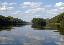
Crossed on Oct. 25th
 |
Facts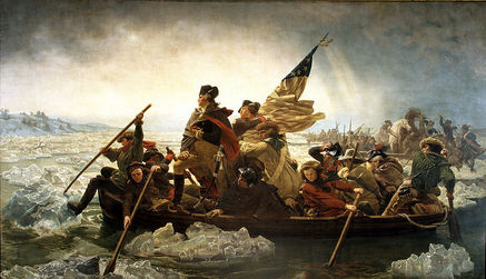
Delaware River From Wikipedia, the free encyclopedia
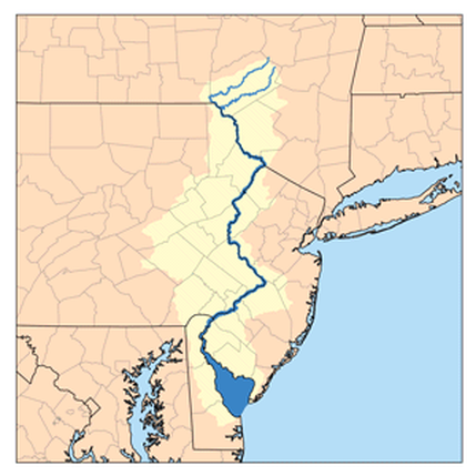
- elevation 2,240 ft (683 m) - coordinates Length 360 mi (579 km) Basin 14,119 sq mi (36,568 km²) The Delaware River is a major river on the Atlantic coast of the United States. The Delaware was explored by Adriaen Block in the early 1600's, as part of the New Netherland, and was named the South River to mark the southernmost reach of that colony. The river meets tide-water at Trenton, New Jersey. Its total length, from the head of the longest branch to Cape May and Cape Henlopen, is 410 miles (660 km), and above the head of the Delaware Bay its length is 360 miles (579 km). The mean freshwater discharge of the Delaware River into the estuary is 11,550 cubic feet (330 m³) per second. The Delaware River constitutes, in part, the boundary between Pennsylvania and New York, the entire boundary between New Jersey and Pennsylvania, and most of the boundary between Delaware and New Jersey. The Delaware-New Jersey Border is actually at the eastern-most river shoreline within the Twelve-Mile Circle of New Castle, rather than the usual mid river or mid channel borders, causing small portions of the New Jersey peninsula falling west of the shoreline to fall under the jurisdiction of Delaware. The rest of the borders follow a mid-channel approach. Commerce was once important on the upper river, primarily prior to railway competition (1857).
In the "project of 1885" the United States government undertook systematically the formation of a 26-foot (7.9 m) channel 600 feet (180 m) wide from Philadelphia to deep water in Delaware Bay. The River and Harbor Act of 1899 provided for a 30-foot (9.1 m) channel 600 feet wide from Philadelphia to the deep water of the bay. Course The main, west or Mohawk branch rises in Schoharie County, New York, about 1,886 feet (575 m) above the sea, near Mount Jefferson, and flows tortuously through the plateau in a deep trough, impounded at one point to create the Cannonsville Reservoir, and then becoming the state boundary of N.Y and Pennsylvania at the 42nd parallel, until it emerges from the Catskills. Similarly, the East Branch begins from a small pond south of Grand Gorge in the town of Roxbury in Delaware County, flowing southward toward its impoundment by New York City to create the Pepacton Reservoir, the largest reservoir in the New York City water supply system. The confluence is just south of Hancock. Delaware above Walpack Bend, where it leaves the buried valley eroded from Marcellus Shale bedrock From Handcock, NY the river flows between the Pocono mountains and the lowered shale beds north of the Catskills. The river flows down a broad Appalachian valley, passing Hawk's Nest overlook on the "Upper Delaware Scenic Byway". At Port Jervis it enters the Port Jervis trough. Below Port Jervis, New York, the Walpack Ridge deflects the Delaware into the Minisink Valley, where it follows the southwest strike of the eroded Marcellus Formation beds along the Pennsylvania–New Jersey state line for 25 miles (40 km) to the end of the ridge at Wallpack Bend in the Delaware Water Gap National Recreation Area.[1][2] The Minisink is a buried valley where the Delaware flows in a bed of glacial till that buried the eroded bedrock during the last glacial period. It then skirts the Kittatinny ridge, which it crosses at the Delaware Water Gap, between nearly vertical walls of sandstone, quartzite, and conglomerate and then passes through a quiet and charming country of farm and forest, diversified with plateaus and escarpments, until it crosses the Appalachian plain and enters the hills again at Easton, Pennsylvania. From this point it is flanked at intervals by fine hills, and in places by cliffs, of which the finest are the Nockamixon Rocks, 3 miles (5 km) long and above 200 feet (61 m) high. At Trenton there is a fall of 8 feet (2.4 m). Below Trenton the river flows between Philadelphia and New Jersey before becoming a broad, sluggish inlet of the sea, with many marshes along its side, widening steadily into its great estuary, Delaware Bay. [edit] Tributaries The main tributaries in New York are the Mongaup, Neversink rivers and Callicoon Creek. From Pennsylvania, the Lackawaxen, Lehigh, and Schuylkill rivers. From New Jersey, the Big Flatbrook, the Pequest, Rancocas Creek, the Musconetcong, Maurice rivers. Oldmans and Raccoon, flow into the Delaware. A 1655 Swedish nautical chart showing part of the Delaware River. The map is from when Delaware River was under the Swedish colony New Sweden. The upper Delaware River near Barryville, New York Canoeing on the river at Hawk's Nest, New York The middle Delaware viewed from Ewing, New Jersey. The lower Delaware as viewed from New Castle, Delaware
More recently, moderate to severe flooding has occurred along the river. The same gauge at Riegelsville recorded a peak of 30.95 feet (9.43 m) on September 23, 2004, 34.07 feet (10.38 m) on April 4, 2005, and 33.62 feet (10.25 m) on June 28, 2006, all considerably higher than the flood stage of 22 feet (6.7 m).[3] Since the upper Delaware basin has few population centers along its banks, flooding in this area mainly affects natural unpopulated flood plains. Residents in the middle part of the Delaware basin experience flooding, including three major floods in the three years (2004–2006) that have severely damaged their homes and land. The lower part of the Delaware basin from Philadelphia southward to the Delaware Bay is tidal and much wider than portions further north, and is not prone to river related flooding (although tidal surges can cause minor flooding in this area). The Delaware River Basin Commission, along with local governments, is working to try to address the issue of flooding along the river. As the past few years have seen a rise in catastrophic floods, most residents of the river basin feel that something must be done. The local governments have worked in association with FEMA to address many of these problems, however, due to insufficient federal funds, progress is slow.[4] [edit] New York City Water Supply After New York City had made 15 reservoirs (with more to come) for their water supply, and with a growing population, the city tried to gain permission to make five reservoirs along the Delaware River's tributaries. However, they were denied the permission to impound the Delaware's tributaries to make new reservoirs. So in 1928, New York City decided to draw water from the Delaware River to feed the population boom that had started during the beginning of the Great Depression. There were, however, villages and towns across the river in Pennsylvania that were already using the Delaware for their water supply. The two sides eventually took their case to the U.S. Supreme Court, and in 1931, New York City was finally allowed to draw 440 million gallons of water a day from the Delaware and its upstream tributaries. [edit] Crossings George Washington crossing the Delaware River prior to the Battle of Trenton Main article: List of crossings of the Delaware River The Delaware River is a major barrier to travel between New Jersey and Pennsylvania. Most of the larger bridges are tolled only westbound, and are owned by the Delaware River and Bay Authority, Delaware River Port Authority, Burlington County Bridge Commission or Delaware River Joint Toll Bridge Commission. [edit] Washington's crossing of the Delaware Main article: Washington's crossing of the Delaware Perhaps the most famous “Delaware Crossing” involved the improvised boat crossing undertaken by George Washington’s army during the American Revolution on Christmas Day, 1776. This led to a successful surprise attack on the Hessian troops occupying Trenton, New Jersey. |
